Alas no walking for me or mine this past week, the smallest puppy dog had a operation and needed to be kept still and quiet - erm hello mr vet shes an English springer spaniel - unless i lock her in the cupboard never gonna happen! And we love her for her energy, wagging tail and lack of being still less its barely light out there. I've managed the week by working from home, and taking her to bed, again not much sleep not the best prep for a walking holiday but she got the all clear today from the vets so its back to it tomorrow.
A round trip commute by my own steam to work tomorrow will stretch my legs 2.7miles, then again on Wednesday, a break on Thursday and then a long walk with the puppies and hubby Friday night, maybe across the downs and then one more on Saturday in the morning, this heat isn't helping walk prep at all! Then Sunday morning the road trip to hull, and a wander over the humber bridge and back, just as a hello to the area and one more thing ticked off our to do list.
Am really looking forward to it, so Yorkshire here we come ;o)
Monday 27 June 2011
Sunday 19 June 2011
Barley mow bridge to Crookham Wharf - basingstoke canal walk 4.92 miles
We decided to try a little bit of canal walking with the little one. JP is 5 years old, has his own pair of walking boots, which we have used quiet a bit in the last 6 months and he walks at least once a fortnight, anywhere from 1.5 miles to 4 miles long. Normally the destination and incentive is a park for him to play in, but we want to try and include him in our walking a little, or at least that's the intention anyway lol.
He carried his own rucksack containing a regatta soft shell jacket, a water bottle, a sunhat and his snack for the walk a box of raspberries, grapes and gooseberries. I have a new larger pack i need to practice carrying, and thought that today would be a good day to try it out, as i knew the pace would be slowly with JP alongside. I filled my rucksack with about 15kilos, added in two waterproof jackets as this weekend has been showers, showers and more showers! I too carried a snack pack of grapes, gooseberries and cherries alongside a box of Bombay mix too! It was to be a short walk, so water and snacks were deemed suitable.
We drove down to the car park opposite the barley mow pub at Winchfield Hurst and parked up. It was about 2pm and warmish so i was back in my shorts, t shirt, thermal socks and walking shoes, as was Gary. JP had those wonderfull kid trousers that roll up and attach to a button and can be rolled down at a quick flick of a finger or too. As we parked and locked up, put on rucksacks we took a "we're ready to go photo" too - just for prosperity!
After the last stretch of the canal being full of dragonfly's, birds and other wildlife it immediately strikes you that this isn't going to be the same. There's no dragonflies and its definitely quieter than the previous walk down the canal. The path is overhung and there are many places where you need to pull in your arms and hop over nettles and brambles - though the canopies of the trees provide a lovely shade and help add to the quiet atmosphere. We passed two narrow boats here, one a disabled access boat with a wheelchair user and his family enjoying the waterway, and the other a group of girls dressed up as if on a party/hen night. Then the first bridge - Blacksmith bridge came up - at about the 1mile mark on the map.
 You quickly come to the next bridge, Double bridge, which was the only bridge we have seen so far that doesn't have a name plate on either side of the bridge, seems a shame that it hasn't got one.
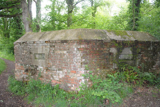
 What you cant fail to notice along this stretch is the amount of former World War II defences that litter both sides of the canal. You can see crumbled down and barely visible air raid shelters, as well as very good condition air raid shelters, pillboxes, and what we later found out from an information plaques, concrete tank traps too.

 And as we came up and around the edge of the bridge we saw a white gull/tern coming back off the river with his tea in his mouth, a small fish. It was a great sight too see, but the best sightings of the day were still to come.
A flash of blue flying so low to the water caught our eyes, and my hubby turned to me and said kingfisher, as i turned to look again it flew back past this time flashing it orange underbelly and swooping back into the far side of trees - i could see the smile he was wearing, despite looking at his back, as the kingfisher is his favourite bird and its a dream to catch it on camera. That wasn't too be, but that he had seen it twice was a joy.
We were very fortunate to see another heron, it could possibly be the same one as before as it was just the other side of the Dogmersfield park estate, which was where we saw the heron on our previous walk. Alas though, this time we were not lucky enough to get anything other than a few blurred pictures, but the sight of the heron unfolding his wings, with a loud bang, and then flying just above the water down the canal, disappearing around the bend was a great sight, and was JP's first sighting of a heron in flight which he enjoyed too. As we walked on further down the canal, with coxmoor wood backing onto the canal it started to rain and so just before the 3 mile mark on the map we stopped to put on JP's coat and have our snacks.As the little one couldn't walk and eat, it not being something he's mastered yet, we stood and ate under the trees, though he can talk and eat and we were discussing what the air raid shelters were used for. What none of us noticed until we started to walk off, was that the heron must have landed and be stood on the far side of the bank, as once again he flew straight past us and off down the river - again a fab sight to see and we were now just a hundred of meters away from from Crookham Wharf and our last bridge for the day, Chequers bridge.
 The car park here, has a lovely etched looking map of the whole canal, so we were able to trace on the plaque where we had just walked. We decided to walk back to WinchfieldWinchfield, and so we left the canal and walked about 500yards on a quiet road to the footpath sign, which helpfully said Dogmersfield on it, confirming we had the right route. Here JP stooped to unroll his trousers down to his boots, because as soon as you stepped over the stile we were walking in a grassland meadow. The great thing about this was as we walked butterflies would fly up off the path and grasses next to the paths, and we saw at least 50 butterflies floating past as we walked. the grasses were still damp from the rains but the path was well used and it was easy to follow, at the end of the first field there was another stile and then across a field used for grazing to another stile.
 Dogmersfield. The entrance to this part of the footpath was overgrown, muddy and steep, filtered with tree roots and very narrow, one by one we walked up until we were now walking around the edge of a field. Nearing the 4 mile mark the going was slower, the little one was tiring but we were nearly there and the pace picked up, in fact it was the 2nd fastest mile. Once across this field that path ran alongside some horses fields and we could once again see the Barleymow pub, right next to the car park. The footpath joined onto the Hart conservation trail just at the end, and as we walked onto the road for a few hundred yards at winchfield we all agreed it was a good day of walking.
Summary:
Date: 19th June 2011
Total walk: 4.92 miles / 7.84km
Descent: 170 ft
Ascent: 165 ft
Average pace: 29.55 mins a mile
Accompanied: Gary Bygrave and JP

He carried his own rucksack containing a regatta soft shell jacket, a water bottle, a sunhat and his snack for the walk a box of raspberries, grapes and gooseberries. I have a new larger pack i need to practice carrying, and thought that today would be a good day to try it out, as i knew the pace would be slowly with JP alongside. I filled my rucksack with about 15kilos, added in two waterproof jackets as this weekend has been showers, showers and more showers! I too carried a snack pack of grapes, gooseberries and cherries alongside a box of Bombay mix too! It was to be a short walk, so water and snacks were deemed suitable.
We drove down to the car park opposite the barley mow pub at Winchfield Hurst and parked up. It was about 2pm and warmish so i was back in my shorts, t shirt, thermal socks and walking shoes, as was Gary. JP had those wonderfull kid trousers that roll up and attach to a button and can be rolled down at a quick flick of a finger or too. As we parked and locked up, put on rucksacks we took a "we're ready to go photo" too - just for prosperity!
After the last stretch of the canal being full of dragonfly's, birds and other wildlife it immediately strikes you that this isn't going to be the same. There's no dragonflies and its definitely quieter than the previous walk down the canal. The path is overhung and there are many places where you need to pull in your arms and hop over nettles and brambles - though the canopies of the trees provide a lovely shade and help add to the quiet atmosphere. We passed two narrow boats here, one a disabled access boat with a wheelchair user and his family enjoying the waterway, and the other a group of girls dressed up as if on a party/hen night. Then the first bridge - Blacksmith bridge came up - at about the 1mile mark on the map.


A flash of blue flying so low to the water caught our eyes, and my hubby turned to me and said kingfisher, as i turned to look again it flew back past this time flashing it orange underbelly and swooping back into the far side of trees - i could see the smile he was wearing, despite looking at his back, as the kingfisher is his favourite bird and its a dream to catch it on camera. That wasn't too be, but that he had seen it twice was a joy.
We were very fortunate to see another heron, it could possibly be the same one as before as it was just the other side of the Dogmersfield park estate, which was where we saw the heron on our previous walk. Alas though, this time we were not lucky enough to get anything other than a few blurred pictures, but the sight of the heron unfolding his wings, with a loud bang, and then flying just above the water down the canal, disappearing around the bend was a great sight, and was JP's first sighting of a heron in flight which he enjoyed too. As we walked on further down the canal, with coxmoor wood backing onto the canal it started to rain and so just before the 3 mile mark on the map we stopped to put on JP's coat and have our snacks.As the little one couldn't walk and eat, it not being something he's mastered yet, we stood and ate under the trees, though he can talk and eat and we were discussing what the air raid shelters were used for. What none of us noticed until we started to walk off, was that the heron must have landed and be stood on the far side of the bank, as once again he flew straight past us and off down the river - again a fab sight to see and we were now just a hundred of meters away from from Crookham Wharf and our last bridge for the day, Chequers bridge.


Summary:
Date: 19th June 2011
Total walk: 4.92 miles / 7.84km
Descent: 170 ft
Ascent: 165 ft
Average pace: 29.55 mins a mile
Accompanied: Gary Bygrave and JP

Monday 13 June 2011
How to choose a weeks worth of holiday walks
I am planning a weeks walking holiday in East Yorkshire beginning 3rd July, and deciding on which walk / what places to walk is proving difficult! There are so many suggested walks to choose from, inland, coastal and heritage that there's truly something for everything.
We are also wanting to have one day of a longer walk between 12-18 miles, and then 4 more days of between 8 - 10 miles of different moderation's, seeing as we are pretty new to walking we don't want to over do it, but also need to increase the length and difficulties of our walks so that we can prepare for some of the longer distance walks which abound around here.
Also we need to consider do we want an established walk or a walk whereby a OS map and navigation is needed - for me that detracts a little from the scenery around you, but again this might just be because I am new to walking for my pleasure. A few directions/instructions of course, but i don't want to miss something because I'm map reading, its not so much fun - again though if i want to take on the challenge of a longer distance path then re-establishing my map reading skills will be essential ;o(
I'm going to try and put an itinerary together this week and report back - if you have any suggestions though please let me know, I'm open to some help ;o)
Sunday 5 June 2011
Basingstoke Canal - Greywell (lock 30) to Barley Mow Bridge and back - 11.69 miles
We decided to have a go at walking some of the Basingstoke canal, so having taken out a book from the local library, we packed some supplies into my pack and off we set. We are still working out how much water/snacks to carry, this appears to be a little hit and miss as we had enough water but not enough energy this time round, so we need to work on this for next time. I was in jean shorts, a short sleeved chlorofibre T-shirt, walking shoes, and carrying around 7lbs in my daysack.As we left the car, parked in the lay by by Greywell water treatment works it was a sunny 19degrees. Walking up through the village the signpost for the canal walk is very easy to miss, it just says footpath and Hampshire countryside services, we weren't the only people to look twice before walking up there, you pass through a space between two back gardens and you are suddenly on top of the greywell tunnel. There is an info board just down the slope, detailing the history and use of the tunnel, as well as some info on the bat population in the tunnel. It is an area of Scientific Special Interest.
 The first thing you notice as you start the walk down the side of the canal is that despite there being some algae and debris on top of the water, the water itself is crystal clear in this section of the canal - turning to the guide book it mentions that the canals main water supply here comes from springs in the greywell cutting and its always ice-cold at this point - it certainly looks it! On the way back just before we finished our walk it would have been lovely to dip our toes just a little lol.
 Just after the next bend in the canal you happen across Odiham castle, and by that i mean it literally does just appear to your left! The castle is commonly known as King Johns castle and is famous as a stop off point on the way to King john singing the magna carta. It's worth having a small detour to look at the ruins, which were being utilised by many people on our way past.

 It doesn't take much imagination at all to be able to see what this octagonal, thick walled keep would have looked like in its heyday, its worth noting that the castle fell into disrepair back in the 15th century and yet some of it remains still now.
As you come to the next bend in the canal you pass your first bridge, the lift bridge across the road - the clarity of the water isn't so clear at all now but that doesn't stop the abundance of wildlife. We saw swans and 7 cygnets off to the left in a feeding pond, as well as numerously coloured dragonfly and damselfly's. I'm pretty sure i remember reading that this stretch of the canal is known for its large amount of dragonfly's and is regarded as one of the best populated sites of scientific interest for this reason. You notice as you walk the glorious colours from a deep sapphire blue, to a brilliant gold, a stunning red and a deep black.


 It was tricky to catch them on camera though you wont miss them with your eyes they are all around you.
You walk on under the swan bridge (all the bridges have plaques on them to that you can monitor where you are on your map) and around another bend in the canal. As you come up to Lodge bridge you notice the farming fields on either side of the canal. It was here that we stopped for some photos of the quiet and empty canal. However, its also here that you notice the noise from the road (A287) just the other side of the field, and it makes you wonder if you've ever driven down that road before, as i have numerous times, how comes you never noticed this great canal and wildlife meters away? It certainly opened my eyes about the undiscovered gems hidden behind the next cow fields.
 You carrying on walking on, and its a very level and easy to walk path, though not suitable for pushchairs due to some patches off overgrowth and very sharp narrowing of the path in places, we both got stung on our arms and legs from the path side nettles. You pass a great picnic area at the Colt Hill Bridge. You can hire canoes from Galleon marine on the opposite side of the canal, and get drinking water and ice creams there too. We stopped on a bench for a quick rest but it was unshaded and the heat was very warm now, so we walked on to find a more covered resting spot. It was great to see so many people using the canal here, as well as another pair of swans and cygnets.
Walking on up the canal path towards board oak bridge was a pleasant stretch, you saw people passing canoeing and enjoying the river, mostly the dads rowing and the wife's and children enjoying being a passenger. As you walk under Broad Oak Bridge you'll find a row of oaks on the left, giving you a nice shaded cover for a couple hundred meters. It was just past here that we saw the sight of the day, just as we passed a large new build house on the right, and 2 narrow boats with the Dogmersfieldbbq stack on the other bank next to the 2 narrow boats,and we considered walking back in case he flew off again but left him. Upon checking the camera though, WOOOHOOO, i had caught him!

 A spring in our step and onwards walking around another bend in the canal brings you to Sandy Hill and Sprats hatch bridges.

I would have to say here that the majority of bike users we passed we decent and either slowed down or waited or vice versa we did to pass each other, but most decided not to dismount under the bridges and it was just past these bridges that the couple walking towards us nearly came a cropper as 4 cyclists sped under the bridge to come to the narrowest part of the path and nearly knock the older guy over. He asked them to get off and push their bikes past him and his wife and when he past us a few feet later was grumpy and mumbling.
We walked on past Basley bridge and Stacey's bridge till the clear mooring area of Barley Mow bridge appeared. this is a great space for mooring and hopping over to the pub for some dinner, drinks or supplies before meandering onwards down the canal. This was the furthest out point for us though at about 5.5miles and 2hrs 25minutes of walking on the maps below. As you come off the canal you walk through a large car park (which will be the start of our next leg down the canal), cross over a b road, and then back on yourself nearly as you see the pub, The barleymow is just in front of you. This afternoon there was a wedding reception going on, and the inside was full, we sat in the shade outside the front doors, and after sharing a larger shandy and a bowl of chips, we decided to head back. Instead of going straight back down the canal path, we started our walk back through the village of Winchfield hurst - we walked along the hurst road, then down to station road (for approx. 2 miles and our fastest paced mile) and we turned left onto a footpath at s bagwell lane which brought us back out at sandy hill bridge. We followed the canal path all the way back from here to Greywell tunnell, spotting another heron on the far bank just after lodge bridge.
It was a great walk, we both ached a little afterwards but had enjoyed the day immensely and would highly recommend it to others.

Summary:
Date: 4th June 2011
Total walk: 11.69 miles / 18.82km
Descent: 145 ft
Ascent: 360 ft
Average pace: 26.05 mins a mile
Accompanied: Gary Bygrave


As you come to the next bend in the canal you pass your first bridge, the lift bridge across the road - the clarity of the water isn't so clear at all now but that doesn't stop the abundance of wildlife. We saw swans and 7 cygnets off to the left in a feeding pond, as well as numerously coloured dragonfly and damselfly's. I'm pretty sure i remember reading that this stretch of the canal is known for its large amount of dragonfly's and is regarded as one of the best populated sites of scientific interest for this reason. You notice as you walk the glorious colours from a deep sapphire blue, to a brilliant gold, a stunning red and a deep black.


You walk on under the swan bridge (all the bridges have plaques on them to that you can monitor where you are on your map) and around another bend in the canal. As you come up to Lodge bridge you notice the farming fields on either side of the canal. It was here that we stopped for some photos of the quiet and empty canal. However, its also here that you notice the noise from the road (A287) just the other side of the field, and it makes you wonder if you've ever driven down that road before, as i have numerous times, how comes you never noticed this great canal and wildlife meters away? It certainly opened my eyes about the undiscovered gems hidden behind the next cow fields.

Walking on up the canal path towards board oak bridge was a pleasant stretch, you saw people passing canoeing and enjoying the river, mostly the dads rowing and the wife's and children enjoying being a passenger. As you walk under Broad Oak Bridge you'll find a row of oaks on the left, giving you a nice shaded cover for a couple hundred meters. It was just past here that we saw the sight of the day, just as we passed a large new build house on the right, and 2 narrow boats with the Dogmersfieldbbq stack on the other bank next to the 2 narrow boats,and we considered walking back in case he flew off again but left him. Upon checking the camera though, WOOOHOOO, i had caught him!


I would have to say here that the majority of bike users we passed we decent and either slowed down or waited or vice versa we did to pass each other, but most decided not to dismount under the bridges and it was just past these bridges that the couple walking towards us nearly came a cropper as 4 cyclists sped under the bridge to come to the narrowest part of the path and nearly knock the older guy over. He asked them to get off and push their bikes past him and his wife and when he past us a few feet later was grumpy and mumbling.
We walked on past Basley bridge and Stacey's bridge till the clear mooring area of Barley Mow bridge appeared. this is a great space for mooring and hopping over to the pub for some dinner, drinks or supplies before meandering onwards down the canal. This was the furthest out point for us though at about 5.5miles and 2hrs 25minutes of walking on the maps below. As you come off the canal you walk through a large car park (which will be the start of our next leg down the canal), cross over a b road, and then back on yourself nearly as you see the pub, The barleymow is just in front of you. This afternoon there was a wedding reception going on, and the inside was full, we sat in the shade outside the front doors, and after sharing a larger shandy and a bowl of chips, we decided to head back. Instead of going straight back down the canal path, we started our walk back through the village of Winchfield hurst - we walked along the hurst road, then down to station road (for approx. 2 miles and our fastest paced mile) and we turned left onto a footpath at s bagwell lane which brought us back out at sandy hill bridge. We followed the canal path all the way back from here to Greywell tunnell, spotting another heron on the far bank just after lodge bridge.
It was a great walk, we both ached a little afterwards but had enjoyed the day immensely and would highly recommend it to others.

Summary:
Date: 4th June 2011
Total walk: 11.69 miles / 18.82km
Descent: 145 ft
Ascent: 360 ft
Average pace: 26.05 mins a mile
Accompanied: Gary Bygrave
Subscribe to:
Posts (Atom)